
Magnitude 4.6 - CELEBES SEA
2011 October 09 12:33:54 UTC
Earthquake Details
- This event has been reviewed by a seismologist.
| Magnitude | 4.6 |
|---|---|
| Date-Time |
|
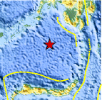
| Location | 4.444°N, 122.903°E |
| Depth | 579.4 km (360.0 miles) |
| Region | CELEBES SEA |
| Distances | 275 km (170 miles) SE of Jolo, Sulu Archipelago, Philippines 288 km (178 miles) SSE of Zamboanga, Mindanao, Philippines 884 km (549 miles) E of BANDAR SERI BEGAWAN, Brunei 1144 km (710 miles) S of MANILA, Philippines |
| Location Uncertainty | horizontal +/- 20.4 km (12.7 miles); depth +/- 10.3 km (6.4 miles) |
| Parameters | NST= 67, Nph= 74, Dmin=495.4 km, Rmss=0.88 sec, Gp= 40°, M-type=body wave magnitude (Mb), Version=4 |
| Source |
|
| Event ID | usc00066pd |
- Did you feel it? Report shaking and damage at your location. You can also view a map displaying accumulated data from your report and others.
Earthquake Maps


Scientific & Technical Information
 Historic Moment Tensor Solutions
- Preliminary Earthquake Report
- U.S. Geological Survey, National Earthquake Information Center:
World Data Center for Seismology, Denver
