
Magnitude 4.6 - EAST OF THE NORTH ISLAND, NEW ZEALAND
2011 October 09 09:53:08 UTC
Earthquake Details
- This event has been reviewed by a seismologist.
| Magnitude | 4.6 |
|---|---|
| Date-Time |
|
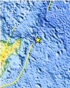
| Location | 37.742°S, 179.717°W |
| Depth | 48.7 km (30.3 miles) |
| Region | EAST OF THE NORTH ISLAND, NEW ZEALAND |
| Distances | 223 km (138 miles) ENE of Gisborne, New Zealand 351 km (218 miles) ENE of Napier, New Zealand 498 km (309 miles) ESE of Auckland, New Zealand 615 km (382 miles) NE of WELLINGTON, New Zealand |
| Location Uncertainty | horizontal +/- 59.6 km (37.0 miles); depth +/- 17.1 km (10.6 miles) |
| Parameters | NST= 31, Nph= 36, Dmin=285 km, Rmss=1.31 sec, Gp=176°, M-type=body wave magnitude (Mb), Version=B |
| Source |
|
| Event ID | usc00066nt |
- Did you feel it? Report shaking and damage at your location. You can also view a map displaying accumulated data from your report and others.
Earthquake Maps


Scientific & Technical Information
 Historic Moment Tensor Solutions
- Preliminary Earthquake Report
- U.S. Geological Survey, National Earthquake Information Center:
World Data Center for Seismology, Denver
