
Magnitude 4.7 - OFF EAST COAST OF THE SOUTH ISLAND, N.Z.
2011 October 09 07:34:38 UTC
Earthquake Details
- This event has been reviewed by a seismologist.
| Magnitude | 4.7 |
|---|---|
| Date-Time |
|
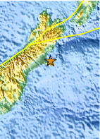
| Location | 43.652°S, 173.023°E |
| Depth | 4.4 km (2.7 miles) (poorly constrained) |
| Region | OFF EAST COAST OF THE SOUTH ISLAND, N.Z. |
| Distances | 30 km (18 miles) ESE of Christchurch, New Zealand 241 km (149 miles) SSE of Westport, New Zealand 299 km (185 miles) SSW of WELLINGTON, New Zealand 317 km (196 miles) NE of Dunedin, New Zealand |
| Location Uncertainty | horizontal +/- 12.7 km (7.9 miles); depth +/- 6.8 km (4.2 miles) |
| Parameters | NST= 35, Nph= 39, Dmin=30.1 km, Rmss=0.48 sec, Gp=191°, M-type=body wave magnitude (Mb), Version=6 |
| Source |
|
| Event ID | usc00066nk |
- Did you feel it? Report shaking and damage at your location. You can also view a map displaying accumulated data from your report and others.
Earthquake Maps


Scientific & Technical Information
 Historic Moment Tensor Solutions
- Preliminary Earthquake Report
- U.S. Geological Survey, National Earthquake Information Center:
World Data Center for Seismology, Denver
