
Magnitude 5.9 - TONGA
2011 October 08 08:53:12 UTC
Earthquake Details
- This event has been reviewed by a seismologist.
| Magnitude | 5.9 |
|---|---|
| Date-Time |
|
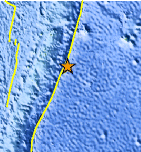
| Location | 20.543°S, 173.189°W |
| Depth | 6.5 km (4.0 miles) |
| Region | TONGA |
| Distances | 216 km (134 miles) ENE of NUKU`ALOFA, Tonga 221 km (137 miles) SSE of Neiafu, Tonga 388 km (241 miles) WSW of Niue Island 2155 km (1339 miles) NE of Auckland, New Zealand |
| Location Uncertainty | horizontal +/- 13.7 km (8.5 miles); depth +/- 4.2 km (2.6 miles) |
| Parameters | NST=467, Nph=505, Dmin=749.2 km, Rmss=0.68 sec, Gp= 22°, M-type=teleseismic moment magnitude (Mw), Version=D |
| Source |
|
| Event ID | usc00066hi |
- Did you feel it? Report shaking and damage at your location. You can also view a map displaying accumulated data from your report and others.
Earthquake Maps


Scientific & Technical Information

 Tsunami Information
The earthquake locations and magnitudes cited in NOAA tsunami statements and bulletins are preliminary and are superseded by USGS locations and magnitudes computed using more extensive data sets.
General Tsunami Information
- Preliminary Earthquake Report
- U.S. Geological Survey, National Earthquake Information Center:
World Data Center for Seismology, Denver
