
Magnitude 5.4 - SOUTHEAST OF THE LOYALTY ISLANDS
2011 October 07 06:30:18 UTC
Earthquake Details
- This event has been reviewed by a seismologist.
| Magnitude | 5.4 |
|---|---|
| Date-Time |
|
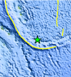
| Location | 22.201°S, 171.202°E |
| Depth | 103.2 km (64.1 miles) |
| Region | SOUTHEAST OF THE LOYALTY ISLANDS |
| Distances | 92 km (57 miles) WNW of Ile Hunter, Loyalty Isl., New Caledonia 348 km (216 miles) ESE of Tadine, Loyalty Islands, New Caledonia 487 km (302 miles) E of NOUMEA, New Caledonia 1663 km (1033 miles) NNW of Auckland, New Zealand |
| Location Uncertainty | horizontal +/- 14.9 km (9.3 miles); depth +/- 6.5 km (4.0 miles) |
| Parameters | NST=237, Nph=249, Dmin=490.9 km, Rmss=0.89 sec, Gp= 25°, M-type=body wave magnitude (Mb), Version=B |
| Source |
|
| Event ID | usc00065w1 |
- Did you feel it? Report shaking and damage at your location. You can also view a map displaying accumulated data from your report and others.
Earthquake Maps


Scientific & Technical Information

 Tsunami Information
The earthquake locations and magnitudes cited in NOAA tsunami statements and bulletins are preliminary and are superseded by USGS locations and magnitudes computed using more extensive data sets.
General Tsunami Information
- Preliminary Earthquake Report
- U.S. Geological Survey, National Earthquake Information Center:
World Data Center for Seismology, Denver
