
Magnitude 4.7 - KERMADEC ISLANDS REGION
2011 October 06 13:59:27 UTC
Earthquake Details
- This event has been reviewed by a seismologist.
| Magnitude | 4.7 |
|---|---|
| Date-Time |
|
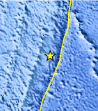
| Location | 29.122°S, 176.944°W |
| Depth | 69.9 km (43.4 miles) |
| Region | KERMADEC ISLANDS REGION |
| Distances |
|
| Location Uncertainty | horizontal +/- 21 km (13.0 miles); depth +/- 6.2 km (3.9 miles) |
| Parameters | NST= 34, Nph= 34, Dmin=96.8 km, Rmss=0.59 sec, Gp=115°, M-type=body wave magnitude (Mb), Version=6 |
| Source |
|
| Event ID | usc00065fg |
- Did you feel it? Report shaking and damage at your location. You can also view a map displaying accumulated data from your report and others.
Earthquake Maps


Scientific & Technical Information
 Historic Moment Tensor Solutions
- Preliminary Earthquake Report
- U.S. Geological Survey, National Earthquake Information Center:
World Data Center for Seismology, Denver
