
Magnitude 4.2 - SUMBAWA REGION, INDONESIA
2011 October 05 22:54:47 UTC
Earthquake Details
- This event has been reviewed by a seismologist.
| Magnitude | 4.2 |
|---|---|
| Date-Time |
|
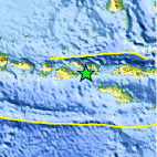
| Location | 8.794°S, 118.378°E |
| Depth | 118.9 km (73.9 miles) |
| Region | SUMBAWA REGION, INDONESIA |
| Distances | 53 km (32 miles) SW of Bima, Sumbawa, Indonesia 228 km (141 miles) WNW of Waingapu, Sumba, Indonesia 250 km (155 miles) E of Mataram, Lombok, Indonesia 792 km (492 miles) W of DILI, Timor-Leste |
| Location Uncertainty | horizontal +/- 67.4 km (41.9 miles); depth +/- 56.6 km (35.2 miles) |
| Parameters | NST= 12, Nph= 12, Dmin=425.2 km, Rmss=1.11 sec, Gp=173°, M-type=body wave magnitude (Mb), Version=F |
| Source |
|
| Event ID | usc000656y |
- Did you feel it? Report shaking and damage at your location. You can also view a map displaying accumulated data from your report and others.

Earthquake Maps


Scientific & Technical Information
 Historic Moment Tensor Solutions
- Preliminary Earthquake Report
- U.S. Geological Survey, National Earthquake Information Center:
World Data Center for Seismology, Denver
