
Magnitude 4.3 - SOLOMON ISLANDS
2011 October 05 15:02:35 UTC
Earthquake Details
- This event has been reviewed by a seismologist.
| Magnitude | 4.3 |
|---|---|
| Date-Time |
|
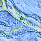
| Location | 7.607°S, 156.223°E |
| Depth | 85.5 km (53.1 miles) |
| Region | SOLOMON ISLANDS |
| Distances | 88 km (54 miles) NW of Gizo, New Georgia Islands, Solomon Isl. 112 km (69 miles) SSW of Chirovanga, Choiseul, Solomon Islands 457 km (283 miles) WNW of HONIARA, Guadalcanal, Solomon Islands 2227 km (1383 miles) N of BRISBANE, Queensland, Australia |
| Location Uncertainty | horizontal +/- 36.9 km (22.9 miles); depth +/- 38.2 km (23.7 miles) |
| Parameters | NST= 13, Nph= 13, Dmin=457.5 km, Rmss=1.12 sec, Gp=108°, M-type=body wave magnitude (Mb), Version=3 |
| Source |
|
| Event ID | usc00064ug |
- Did you feel it? Report shaking and damage at your location. You can also view a map displaying accumulated data from your report and others.
Earthquake Maps


Scientific & Technical Information
 Historic Moment Tensor Solutions
- Preliminary Earthquake Report
- U.S. Geological Survey, National Earthquake Information Center:
World Data Center for Seismology, Denver
