
Magnitude 4.8 - MINDANAO, PHILIPPINES
2011 October 05 07:34:49 UTC
Earthquake Details
- This event has been reviewed by a seismologist.
| Magnitude | 4.8 |
|---|---|
| Date-Time |
|
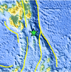
| Location | 5.380°N, 126.766°E |
| Depth | 112.3 km (69.8 miles) |
| Region | MINDANAO, PHILIPPINES |
| Distances | 194 km (120 miles) ESE of General Santos, Mindanao, Philippines 226 km (140 miles) SE of Davao, Mindanao, Philippines 881 km (547 miles) WSW of KOROR, Palau 1201 km (746 miles) SSE of MANILA, Philippines |
| Location Uncertainty | horizontal +/- 32.9 km (20.4 miles); depth +/- 14.3 km (8.9 miles) |
| Parameters | NST= 21, Nph= 23, Dmin=228.2 km, Rmss=0.72 sec, Gp=166°, M-type=body wave magnitude (Mb), Version=4 |
| Source |
|
| Event ID | usc00064ng |
- Did you feel it? Report shaking and damage at your location. You can also view a map displaying accumulated data from your report and others.

Earthquake Maps


Scientific & Technical Information
 Historic Moment Tensor Solutions
- Preliminary Earthquake Report
- U.S. Geological Survey, National Earthquake Information Center:
World Data Center for Seismology, Denver
