
Magnitude 4.7 - SAVU SEA
2011 October 04 12:27:59 UTC
Earthquake Details
- This event has been reviewed by a seismologist.
| Magnitude | 4.7 |
|---|---|
| Date-Time |
|
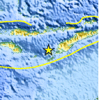
| Location | 10.053°S, 122.942°E |
| Depth | 55.5 km (34.5 miles) |
| Region | SAVU SEA |
| Distances | 71 km (44 miles) W of Kupang, Timor, Indonesia 195 km (121 miles) SE of Ende, Flores, Indonesia 333 km (206 miles) WSW of DILI, Timor-Leste 902 km (560 miles) WNW of DARWIN, Northern Territory, Australia |
| Location Uncertainty | horizontal +/- 24.1 km (15.0 miles); depth +/- 12.2 km (7.6 miles) |
| Parameters | NST= 27, Nph= 36, Dmin=149.2 km, Rmss=1.57 sec, Gp= 83°, M-type=body wave magnitude (Mb), Version=A |
| Source |
|
| Event ID | usc00064af |
- Did you feel it? Report shaking and damage at your location. You can also view a map displaying accumulated data from your report and others.

Earthquake Maps


Scientific & Technical Information
 Historic Moment Tensor Solutions
- Preliminary Earthquake Report
- U.S. Geological Survey, National Earthquake Information Center:
World Data Center for Seismology, Denver
