
Magnitude 4.7 - NEW IRELAND REGION, PAPUA NEW GUINEA
2011 October 04 09:26:54 UTC
Earthquake Details
- This event has been reviewed by a seismologist.
| Magnitude | 4.7 |
|---|---|
| Date-Time |
|
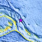
| Location | 3.911°S, 153.941°E |
| Depth | 409.4 km (254.4 miles) |
| Region | NEW IRELAND REGION, PAPUA NEW GUINEA |
| Distances | 118 km (73 miles) ENE of Taron, New Ireland, PNG 197 km (122 miles) E of Rabaul, New Britain, PNG 902 km (560 miles) NW of HONIARA, Guadalcanal, Solomon Islands 2613 km (1623 miles) N of BRISBANE, Queensland, Australia |
| Location Uncertainty | horizontal +/- 17.4 km (10.8 miles); depth +/- 11.4 km (7.1 miles) |
| Parameters | NST= 63, Nph= 73, Dmin=199.3 km, Rmss=0.68 sec, Gp= 65°, M-type=body wave magnitude (Mb), Version=7 |
| Source |
|
| Event ID | usc0006493 |
- Did you feel it? Report shaking and damage at your location. You can also view a map displaying accumulated data from your report and others.

Earthquake Maps


Scientific & Technical Information
 Historic Moment Tensor Solutions
- Preliminary Earthquake Report
- U.S. Geological Survey, National Earthquake Information Center:
World Data Center for Seismology, Denver
