
Magnitude 4.9 - SUMBA REGION, INDONESIA
2011 October 03 22:08:05 UTC
Earthquake Details
- This event has been reviewed by a seismologist.
| Magnitude | 4.9 |
|---|---|
| Date-Time |
|
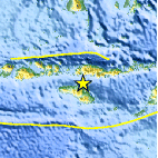
| Location | 9.282°S, 120.206°E |
| Depth | 69.9 km (43.4 miles) |
| Region | SUMBA REGION, INDONESIA |
| Distances | 41 km (25 miles) N of Waingapu, Sumba, Indonesia 165 km (102 miles) WSW of Ende, Flores, Indonesia 595 km (369 miles) W of DILI, Timor-Leste 1214 km (754 miles) WNW of DARWIN, Northern Territory, Australia |
| Location Uncertainty | horizontal +/- 19.5 km (12.1 miles); depth +/- 12 km (7.5 miles) |
| Parameters | NST= 35, Nph= 42, Dmin=234.9 km, Rmss=1.45 sec, Gp= 76°, M-type=body wave magnitude (Mb), Version=5 |
| Source |
|
| Event ID | usc0006449 |
- Did you feel it? Report shaking and damage at your location. You can also view a map displaying accumulated data from your report and others.

Earthquake Maps


Scientific & Technical Information
 Historic Moment Tensor Solutions
- Preliminary Earthquake Report
- U.S. Geological Survey, National Earthquake Information Center:
World Data Center for Seismology, Denver
