
Magnitude 4.8 - TONGA
2011 October 03 05:10:32 UTC
Earthquake Details
- This event has been reviewed by a seismologist.
| Magnitude | 4.8 |
|---|---|
| Date-Time |
|
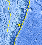
| Location | 21.480°S, 174.350°W |
| Depth | 39.4 km (24.5 miles) |
| Region | TONGA |
| Distances | 96 km (59 miles) ESE of NUKU`ALOFA, Tonga 315 km (195 miles) S of Neiafu, Tonga 461 km (286 miles) ESE of Ndoi Island, Fiji 2004 km (1245 miles) NE of Auckland, New Zealand |
| Location Uncertainty | horizontal +/- 21.1 km (13.1 miles); depth +/- 7.4 km (4.6 miles) |
| Parameters | NST= 51, Nph= 52, Dmin=881.7 km, Rmss=0.93 sec, Gp=130°, M-type=body wave magnitude (Mb), Version=5 |
| Source |
|
| Event ID | usc00063ry |
- Did you feel it? Report shaking and damage at your location. You can also view a map displaying accumulated data from your report and others.
Earthquake Maps


Scientific & Technical Information
 Historic Moment Tensor Solutions
- Preliminary Earthquake Report
- U.S. Geological Survey, National Earthquake Information Center:
World Data Center for Seismology, Denver
