
Magnitude 4.8 - MOLUCCA SEA
2011 October 02 14:39:12 UTC
Earthquake Details
- This event has been reviewed by a seismologist.
| Magnitude | 4.8 |
|---|---|
| Date-Time |
|
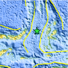
| Location | 1.458°N, 126.314°E |
| Depth | 46.9 km (29.1 miles) |
| Region | MOLUCCA SEA |
| Distances | 141 km (87 miles) WNW of Ternate, Moluccas, Indonesia 163 km (101 miles) E of Manado, Sulawesi, Indonesia 1110 km (689 miles) N of DILI, Timor-Leste 1567 km (973 miles) SSE of MANILA, Philippines |
| Location Uncertainty | horizontal +/- 20.5 km (12.7 miles); depth +/- 8.7 km (5.4 miles) |
| Parameters | NST= 35, Nph= 35, Dmin=819.3 km, Rmss=0.63 sec, Gp= 90°, M-type=body wave magnitude (Mb), Version=5 |
| Source |
|
| Event ID | usc00063i6 |
- Did you feel it? Report shaking and damage at your location. You can also view a map displaying accumulated data from your report and others.

Earthquake Maps


Scientific & Technical Information
 Historic Moment Tensor Solutions
- Preliminary Earthquake Report
- U.S. Geological Survey, National Earthquake Information Center:
World Data Center for Seismology, Denver
