
Magnitude 4.7 - SOUTH OF THE KERMADEC ISLANDS
2011 October 02 06:37:40 UTC
Earthquake Details
- This event has been reviewed by a seismologist.
| Magnitude | 4.7 |
|---|---|
| Date-Time |
|
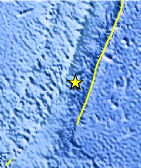
| Location | 33.034°S, 178.751°W |
| Depth | 35 km (21.7 miles) |
| Region | SOUTH OF THE KERMADEC ISLANDS |
| Distances | 177 km (109 miles) S of L'Esperance Rock, Kermadec Islands 425 km (264 miles) S of Raoul Island, Kermadec Islands 729 km (452 miles) NE of Auckland, New Zealand 1081 km (671 miles) NE of WELLINGTON, New Zealand |
| Location Uncertainty | horizontal +/- 30.2 km (18.8 miles); depth +/- 4.8 km (3.0 miles) |
| Parameters | NST= 27, Nph= 28, Dmin=427.5 km, Rmss=0.49 sec, Gp=169°, M-type=body wave magnitude (Mb), Version=6 |
| Source |
|
| Event ID | usc00063g0 |
- Did you feel it? Report shaking and damage at your location. You can also view a map displaying accumulated data from your report and others.
Earthquake Maps


Scientific & Technical Information
 Historic Moment Tensor Solutions
- Preliminary Earthquake Report
- U.S. Geological Survey, National Earthquake Information Center:
World Data Center for Seismology, Denver
