
Magnitude 4.5 - LUZON, PHILIPPINES
2011 October 01 19:28:52 UTC
Earthquake Details
- This event has been reviewed by a seismologist.
| Magnitude | 4.5 |
|---|---|
| Date-Time |
|
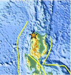
| Location | 18.276°N, 120.767°E |
| Depth | 31.2 km (19.4 miles) |
| Region | LUZON, PHILIPPINES |
| Distances | 20 km (12 miles) ENE of Laoag, Luzon, Philippines 172 km (106 miles) NW of Ilagan, Luzon, Philippines 207 km (128 miles) N of Baguio, Luzon, Philippines 407 km (252 miles) N of MANILA, Philippines |
| Location Uncertainty | horizontal +/- 26 km (16.2 miles); depth +/- 12.7 km (7.9 miles) |
| Parameters | NST= 30, Nph= 37, Dmin=86.8 km, Rmss=1.01 sec, Gp=155°, M-type=body wave magnitude (Mb), Version=4 |
| Source |
|
| Event ID | usc00063c4 |
- Did you feel it? Report shaking and damage at your location. You can also view a map displaying accumulated data from your report and others.

Earthquake Maps


Scientific & Technical Information
 Historic Moment Tensor Solutions
- Preliminary Earthquake Report
- U.S. Geological Survey, National Earthquake Information Center:
World Data Center for Seismology, Denver
