
Magnitude 4.6 - BANDA SEA
2011 October 01 14:17:10 UTC
Earthquake Details
- This event has been reviewed by a seismologist.
| Magnitude | 4.6 |
|---|---|
| Date-Time |
|
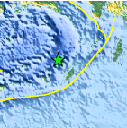
| Location | 6.755°S, 130.642°E |
| Depth | 129.6 km (80.5 miles) |
| Region | BANDA SEA |
| Distances | 151 km (93 miles) NNW of Saumlaki, Kepulauan Tanimbar, Indonesia 410 km (254 miles) WSW of Dobo, Kepulauan Aru, Indonesia 593 km (368 miles) ENE of DILI, Timor-Leste 632 km (392 miles) N of DARWIN, Northern Territory, Australia |
| Location Uncertainty | horizontal +/- 33.8 km (21.0 miles); depth +/- 14.7 km (9.1 miles) |
| Parameters | NST= 22, Nph= 22, Dmin=153.6 km, Rmss=0.91 sec, Gp=119°, M-type=body wave magnitude (Mb), Version=5 |
| Source |
|
| Event ID | usc000639i |
- Did you feel it? Report shaking and damage at your location. You can also view a map displaying accumulated data from your report and others.

Earthquake Maps


Scientific & Technical Information
 Historic Moment Tensor Solutions
- Preliminary Earthquake Report
- U.S. Geological Survey, National Earthquake Information Center:
World Data Center for Seismology, Denver
