
Magnitude 5.6 - OFF WEST COAST OF THE SOUTH ISLAND, N.Z.
2011 October 01 10:54:34 UTC
Earthquake Details
- This event has been reviewed by a seismologist.
| Magnitude | 5.6 |
|---|---|
| Date-Time |
|
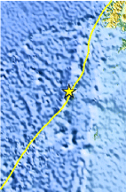
| Location | 48.967°S, 164.348°E |
| Depth | 34.9 km (21.7 miles) |
| Region | OFF WEST COAST OF THE SOUTH ISLAND, N.Z. |
| Distances | 232 km (144 miles) NW of Auckland Island, New Zealand 414 km (257 miles) SW of Invercargill, New Zealand 546 km (339 miles) SW of Queenstown, New Zealand 1181 km (733 miles) SW of WELLINGTON, New Zealand |
| Location Uncertainty | horizontal +/- 18.5 km (11.5 miles); depth +/- 2.9 km (1.8 miles) |
| Parameters | NST= 85, Nph= 89, Dmin=357.3 km, Rmss=1.16 sec, Gp= 86°, M-type=body wave magnitude (Mb), Version=6 |
| Source |
|
| Event ID | usc000638g |
- Did you feel it? Report shaking and damage at your location. You can also view a map displaying accumulated data from your report and others.
Earthquake Maps


Scientific & Technical Information

 Tsunami Information
The earthquake locations and magnitudes cited in NOAA tsunami statements and bulletins are preliminary and are superseded by USGS locations and magnitudes computed using more extensive data sets.
General Tsunami Information
- Preliminary Earthquake Report
- U.S. Geological Survey, National Earthquake Information Center:
World Data Center for Seismology, Denver
