
Magnitude 4.8 - TONGA
2011 October 01 10:16:41 UTC
Earthquake Details
- This event has been reviewed by a seismologist.
| Magnitude | 4.8 |
|---|---|
| Date-Time |
|
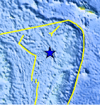
| Location | 17.104°S, 175.020°W |
| Depth | 204.1 km (126.8 miles) |
| Region | TONGA |
| Distances | 185 km (114 miles) SW of Hihifo, Tonga 203 km (126 miles) NNW of Neiafu, Tonga 438 km (272 miles) SSE of MATA'UTU, Ile Uvea, Wallis and Futuna 2410 km (1497 miles) NNE of Auckland, New Zealand |
| Location Uncertainty | horizontal +/- 21.3 km (13.2 miles); depth +/- 10.5 km (6.5 miles) |
| Parameters | NST=154, Nph=155, Dmin=>999 km, Rmss=0.64 sec, Gp= 83°, M-type=body wave magnitude (Mb), Version=9 |
| Source |
|
| Event ID | usc0006386 |
- Did you feel it? Report shaking and damage at your location. You can also view a map displaying accumulated data from your report and others.
Earthquake Maps


Scientific & Technical Information
 Historic Moment Tensor Solutions
- Preliminary Earthquake Report
- U.S. Geological Survey, National Earthquake Information Center:
World Data Center for Seismology, Denver
