
Magnitude 4.6 - VANUATU
2011 September 30 01:27:27 UTC
Earthquake Details
- This event has been reviewed by a seismologist.
| Magnitude | 4.6 |
|---|---|
| Date-Time |
|
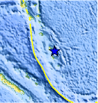
| Location | 19.043°S, 169.464°E |
| Depth | 279.5 km (173.7 miles) |
| Region | VANUATU |
| Distances | 59 km (36 miles) NNE of Isangel, Tanna, Vanuatu 188 km (116 miles) SE of PORT-VILA, Efate, Vanuatu 323 km (200 miles) NNE of Tadine, Loyalty Islands, New Caledonia 1923 km (1194 miles) ENE of BRISBANE, Queensland, Australia |
| Location Uncertainty | horizontal +/- 21.4 km (13.3 miles); depth +/- 12.4 km (7.7 miles) |
| Parameters | NST= 61, Nph= 63, Dmin=459.7 km, Rmss=0.49 sec, Gp= 79°, M-type=body wave magnitude (Mb), Version=3 |
| Source |
|
| Event ID | usc00062ph |
- Did you feel it? Report shaking and damage at your location. You can also view a map displaying accumulated data from your report and others.
Earthquake Maps


Scientific & Technical Information
 Historic Moment Tensor Solutions
- Preliminary Earthquake Report
- U.S. Geological Survey, National Earthquake Information Center:
World Data Center for Seismology, Denver
