
Magnitude 4.4 - FIJI REGION
2011 September 29 10:23:54 UTC
Earthquake Details
- This event has been reviewed by a seismologist.
| Magnitude | 4.4 |
|---|---|
| Date-Time |
|
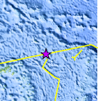
| Location | 15.326°S, 177.242°W |
| Depth | 389.6 km (242.1 miles) |
| Region | FIJI REGION |
| Distances | 151 km (93 miles) SE of Sigave, Ile Futuna, Wallis and Futuna 256 km (159 miles) SSW of MATA'UTU, Ile Uvea, Wallis and Futuna 380 km (236 miles) W of Hihifo, Tonga 2514 km (1562 miles) NNE of Auckland, New Zealand |
| Location Uncertainty | horizontal +/- 31.3 km (19.4 miles); depth +/- 14.2 km (8.8 miles) |
| Parameters | NST=107, Nph=107, Dmin=568.8 km, Rmss=0.59 sec, Gp=108°, M-type=body wave magnitude (Mb), Version=5 |
| Source |
|
| Event ID | usc0006253 |
- Did you feel it? Report shaking and damage at your location. You can also view a map displaying accumulated data from your report and others.
Earthquake Maps


Scientific & Technical Information
 Historic Moment Tensor Solutions
- Preliminary Earthquake Report
- U.S. Geological Survey, National Earthquake Information Center:
World Data Center for Seismology, Denver
