
Magnitude 4.9 - PHILIPPINE ISLANDS REGION
2011 September 29 05:16:33 UTC
Earthquake Details
- This event has been reviewed by a seismologist.
| Magnitude | 4.9 |
|---|---|
| Date-Time |
|
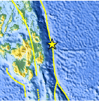
| Location | 8.493°N, 127.180°E |
| Depth | 42 km (26.1 miles) |
| Region | PHILIPPINE ISLANDS REGION |
| Distances | 94 km (58 miles) E of Hinatuan, Mindanao, Philippines 187 km (116 miles) ESE of Butuan, Mindanao, Philippines 816 km (507 miles) W of KOROR, Palau 956 km (594 miles) SE of MANILA, Philippines |
| Location Uncertainty | horizontal +/- 17.9 km (11.1 miles); depth +/- 11 km (6.8 miles) |
| Parameters | NST= 49, Nph= 49, Dmin=237.1 km, Rmss=0.71 sec, Gp= 83°, M-type=body wave magnitude (Mb), Version=7 |
| Source |
|
| Event ID | usc0006247 |
- Did you feel it? Report shaking and damage at your location. You can also view a map displaying accumulated data from your report and others.
Earthquake Maps


Scientific & Technical Information
 Historic Moment Tensor Solutions
- Preliminary Earthquake Report
- U.S. Geological Survey, National Earthquake Information Center:
World Data Center for Seismology, Denver
