
Magnitude 4.6 - KEPULAUAN TANIMBAR REGION, INDONESIA
2011 September 29 00:27:11 UTC
Earthquake Details
- This event has been reviewed by a seismologist.
| Magnitude | 4.6 |
|---|---|
| Date-Time |
|
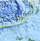
| Location | 7.583°S, 130.674°E |
| Depth | 35 km (21.7 miles) |
| Region | KEPULAUAN TANIMBAR REGION, INDONESIA |
| Distances | 82 km (50 miles) WNW of Saumlaki, Kepulauan Tanimbar, Indonesia 440 km (273 miles) WSW of Dobo, Kepulauan Aru, Indonesia 510 km (316 miles) SSE of Ambon, Moluccas, Indonesia 540 km (335 miles) N of DARWIN, Northern Territory, Australia |
| Location Uncertainty | horizontal +/- 32.5 km (20.2 miles); depth +/- 5 km (3.1 miles) |
| Parameters | NST= 21, Nph= 21, Dmin=584.4 km, Rmss=1.26 sec, Gp=137°, M-type=body wave magnitude (Mb), Version=A |
| Source |
|
| Event ID | usc000623c |
- Did you feel it? Report shaking and damage at your location. You can also view a map displaying accumulated data from your report and others.

Earthquake Maps


Scientific & Technical Information
 Historic Moment Tensor Solutions
- Preliminary Earthquake Report
- U.S. Geological Survey, National Earthquake Information Center:
World Data Center for Seismology, Denver
