
Magnitude 4.8 - NEW BRITAIN REGION, PAPUA NEW GUINEA
2011 September 27 00:46:17 UTC
Earthquake Details
- This event has been reviewed by a seismologist.
| Magnitude | 4.8 |
|---|---|
| Date-Time |
|
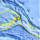
| Location | 4.738°S, 152.698°E |
| Depth | 65 km (40.4 miles) |
| Region | NEW BRITAIN REGION, PAPUA NEW GUINEA |
| Distances | 47 km (29 miles) SW of Taron, New Ireland, PNG 82 km (50 miles) SE of Rabaul, New Britain, PNG 801 km (497 miles) NE of PORT MORESBY, Papua New Guinea 2519 km (1565 miles) N of BRISBANE, Queensland, Australia |
| Location Uncertainty | horizontal +/- 16.7 km (10.4 miles); depth +/- 9.9 km (6.2 miles) |
| Parameters | NST= 67, Nph= 70, Dmin=84.6 km, Rmss=0.85 sec, Gp= 47°, M-type=body wave magnitude (Mb), Version=6 |
| Source |
|
| Event ID | usc00060yh |
- Did you feel it? Report shaking and damage at your location. You can also view a map displaying accumulated data from your report and others.

Earthquake Maps


Scientific & Technical Information
 Historic Moment Tensor Solutions
- Preliminary Earthquake Report
- U.S. Geological Survey, National Earthquake Information Center:
World Data Center for Seismology, Denver
