
Magnitude 4.9 - SOUTHEAST OF THE LOYALTY ISLANDS
2011 September 25 09:46:51 UTC
Earthquake Details
- This event has been reviewed by a seismologist.
| Magnitude | 4.9 |
|---|---|
| Date-Time |
|
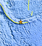
| Location | 22.884°S, 171.915°E |
| Depth | 30.9 km (19.2 miles) |
| Region | SOUTHEAST OF THE LOYALTY ISLANDS |
| Distances | 55 km (34 miles) SSW of Ile Hunter, Loyalty Isl., New Caledonia 302 km (187 miles) WSW of Ceva-i-Ra, Fiji 565 km (351 miles) E of NOUMEA, New Caledonia 1575 km (978 miles) N of Auckland, New Zealand |
| Location Uncertainty | horizontal +/- 18.6 km (11.6 miles); depth +/- 3.7 km (2.3 miles) |
| Parameters | NST= 44, Nph= 44, Dmin=570 km, Rmss=0.81 sec, Gp= 50°, M-type=body wave magnitude (Mb), Version=6 |
| Source |
|
| Event ID | usc000606m |
- Did you feel it? Report shaking and damage at your location. You can also view a map displaying accumulated data from your report and others.
Earthquake Maps


Scientific & Technical Information
 Historic Moment Tensor Solutions
- Preliminary Earthquake Report
- U.S. Geological Survey, National Earthquake Information Center:
World Data Center for Seismology, Denver
