
Magnitude 5.1 - FIJI REGION
2011 September 24 05:27:48 UTC
Earthquake Details
- This event has been reviewed by a seismologist.
| Magnitude | 5.1 |
|---|---|
| Date-Time |
|
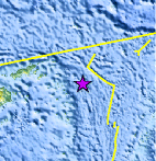
| Location | 17.238°S, 177.763°W |
| Depth | 380.2 km (236.3 miles) |
| Region | FIJI REGION |
| Distances | 317 km (196 miles) ESE of Lambasa, Vanua Levu, Fiji 328 km (203 miles) S of Sigave, Ile Futuna, Wallis and Futuna 417 km (259 miles) ENE of SUVA, Viti Levu, Fiji 2296 km (1426 miles) NNE of Auckland, New Zealand |
| Location Uncertainty | horizontal +/- 18.9 km (11.7 miles); depth +/- 10.7 km (6.6 miles) |
| Parameters | NST=244, Nph=245, Dmin=447.5 km, Rmss=0.86 sec, Gp=115°, M-type=body wave magnitude (Mb), Version=6 |
| Source |
|
| Event ID | usc0005zwk |
- Did you feel it? Report shaking and damage at your location. You can also view a map displaying accumulated data from your report and others.
Earthquake Maps


Scientific & Technical Information
 Historic Moment Tensor Solutions
 Tsunami Information
The earthquake locations and magnitudes cited in NOAA tsunami statements and bulletins are preliminary and are superseded by USGS locations and magnitudes computed using more extensive data sets.
General Tsunami Information
- Preliminary Earthquake Report
- U.S. Geological Survey, National Earthquake Information Center:
World Data Center for Seismology, Denver
