
Magnitude 5.2 - NEW BRITAIN REGION, PAPUA NEW GUINEA
2011 September 24 02:57:52 UTC
Earthquake Details
- This event has been reviewed by a seismologist.
| Magnitude | 5.2 |
|---|---|
| Date-Time |
|
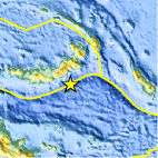
| Location | 6.337°S, 151.564°E |
| Depth | 67 km (41.6 miles) |
| Region | NEW BRITAIN REGION, PAPUA NEW GUINEA |
| Distances | 178 km (110 miles) ESE of Kimbe, New Britain, PNG 222 km (137 miles) E of Kandrian, New Britain, PNG 592 km (367 miles) NE of PORT MORESBY, Papua New Guinea 2347 km (1458 miles) N of BRISBANE, Queensland, Australia |
| Location Uncertainty | horizontal +/- 15.8 km (9.8 miles); depth +/- 10.7 km (6.6 miles) |
| Parameters | NST= 97, Nph= 99, Dmin=246 km, Rmss=0.82 sec, Gp= 61°, M-type=body wave magnitude (Mb), Version=5 |
| Source |
|
| Event ID | usc0005zvj |
- Did you feel it? Report shaking and damage at your location. You can also view a map displaying accumulated data from your report and others.

Earthquake Maps


Scientific & Technical Information
 Historic Moment Tensor Solutions
 Tsunami Information
The earthquake locations and magnitudes cited in NOAA tsunami statements and bulletins are preliminary and are superseded by USGS locations and magnitudes computed using more extensive data sets.
General Tsunami Information
- Preliminary Earthquake Report
- U.S. Geological Survey, National Earthquake Information Center:
World Data Center for Seismology, Denver
