
Magnitude 4.6 - MINDANAO, PHILIPPINES
2011 September 20 21:44:19 UTC
Earthquake Details
- This event has been reviewed by a seismologist.
| Magnitude | 4.6 |
|---|---|
| Date-Time |
|
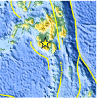
| Location | 6.477°N, 124.733°E |
| Depth | 42.7 km (26.5 miles) |
| Region | MINDANAO, PHILIPPINES |
| Distances | 63 km (39 miles) NW of General Santos, Mindanao, Philippines 98 km (60 miles) SSE of Cotabato, Mindanao, Philippines 117 km (72 miles) SW of Davao, Mindanao, Philippines 988 km (613 miles) SSE of MANILA, Philippines |
| Location Uncertainty | horizontal +/- 19.8 km (12.3 miles); depth +/- 10.8 km (6.7 miles) |
| Parameters | NST= 25, Nph= 26, Dmin=114.7 km, Rmss=0.83 sec, Gp=104°, M-type=body wave magnitude (Mb), Version=7 |
| Source |
|
| Event ID | usc0005xl5 |
- Did you feel it? Report shaking and damage at your location. You can also view a map displaying accumulated data from your report and others.

Earthquake Maps


Scientific & Technical Information
 Historic Moment Tensor Solutions
- Preliminary Earthquake Report
- U.S. Geological Survey, National Earthquake Information Center:
World Data Center for Seismology, Denver
