
Magnitude 4.8 - PAPUA, INDONESIA
2011 September 20 03:48:49 UTC
Earthquake Details
- This event has been reviewed by a seismologist.
| Magnitude | 4.8 |
|---|---|
| Date-Time |
|
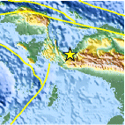
| Location | 3.521°S, 135.487°E |
| Depth | 38.1 km (23.7 miles) |
| Region | PAPUA, INDONESIA |
| Distances | 108 km (67 miles) WNW of Enarotali, Papua, Indonesia 285 km (177 miles) NNE of Dobo, Kepulauan Aru, Indonesia 1115 km (692 miles) NNE of DARWIN, Northern Territory, Australia 3192 km (1983 miles) E of JAKARTA, Java, Indonesia |
| Location Uncertainty | horizontal +/- 24.4 km (15.2 miles); depth +/- 8 km (5.0 miles) |
| Parameters | NST= 26, Nph= 31, Dmin=366.2 km, Rmss=1.19 sec, Gp= 94°, M-type=body wave magnitude (Mb), Version=4 |
| Source |
|
| Event ID | usc0005x6i |
- Did you feel it? Report shaking and damage at your location. You can also view a map displaying accumulated data from your report and others.

Earthquake Maps


Scientific & Technical Information
 Historic Moment Tensor Solutions
- Preliminary Earthquake Report
- U.S. Geological Survey, National Earthquake Information Center:
World Data Center for Seismology, Denver
