
Magnitude 4.8 - NEAR THE NORTH COAST OF PAPUA, INDONESIA
2011 September 20 02:31:07 UTC
Earthquake Details
- This event has been reviewed by a seismologist.
| Magnitude | 4.8 |
|---|---|
| Date-Time |
|
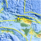
| Location | 0.643°S, 131.607°E |
| Depth | 40.7 km (25.3 miles) |
| Region | NEAR THE NORTH COAST OF PAPUA, INDONESIA |
| Distances | 48 km (29 miles) ENE of Sorong, Papua, Indonesia 276 km (171 miles) W of Manokwari, Papua, Indonesia 939 km (583 miles) SSW of KOROR, Palau 1311 km (814 miles) N of DARWIN, Northern Territory, Australia |
| Location Uncertainty | horizontal +/- 47.2 km (29.3 miles); depth +/- 10.9 km (6.8 miles) |
| Parameters | NST= 23, Nph= 27, Dmin=261.6 km, Rmss=0.76 sec, Gp=130°, M-type=body wave magnitude (Mb), Version=4 |
| Source |
|
| Event ID | usc0005x5z |
- Did you feel it? Report shaking and damage at your location. You can also view a map displaying accumulated data from your report and others.

Earthquake Maps


Scientific & Technical Information
 Historic Moment Tensor Solutions
- Preliminary Earthquake Report
- U.S. Geological Survey, National Earthquake Information Center:
World Data Center for Seismology, Denver
