
Magnitude 4.7 - NEW BRITAIN REGION, PAPUA NEW GUINEA
2011 September 19 21:31:47 UTC
Earthquake Details
- This event has been reviewed by a seismologist.
| Magnitude | 4.7 |
|---|---|
| Date-Time |
|
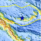
| Location | 5.587°S, 149.325°E |
| Depth | 172.1 km (106.9 miles) |
| Region | NEW BRITAIN REGION, PAPUA NEW GUINEA |
| Distances | 73 km (45 miles) NNW of Kandrian, New Britain, PNG 90 km (55 miles) W of Kimbe, New Britain, PNG 489 km (303 miles) NNE of PORT MORESBY, Papua New Guinea 2456 km (1526 miles) N of BRISBANE, Queensland, Australia |
| Location Uncertainty | horizontal +/- 16 km (9.9 miles); depth +/- 7.6 km (4.7 miles) |
| Parameters | NST= 60, Nph= 75, Dmin=350.7 km, Rmss=1.44 sec, Gp= 72°, M-type=body wave magnitude (Mb), Version=6 |
| Source |
|
| Event ID | usc0005x2t |
- Did you feel it? Report shaking and damage at your location. You can also view a map displaying accumulated data from your report and others.

Earthquake Maps


Scientific & Technical Information
 Historic Moment Tensor Solutions
- Preliminary Earthquake Report
- U.S. Geological Survey, National Earthquake Information Center:
World Data Center for Seismology, Denver
