
Magnitude 4.0 - SOUTH ISLAND OF NEW ZEALAND
2011 September 19 01:51:30 UTC
Earthquake Details
- This event has been reviewed by a seismologist.
| Magnitude | 4.0 |
|---|---|
| Date-Time |
|
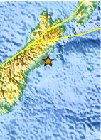
| Location | 43.620°S, 172.800°E |
| Depth | 12 km (7.5 miles) |
| Region | SOUTH ISLAND OF NEW ZEALAND |
| Distances | 13 km (8 miles) SE of Christchurch, New Zealand 229 km (142 miles) SSE of Westport, New Zealand 305 km (189 miles) SSW of WELLINGTON, New Zealand 309 km (192 miles) NE of Dunedin, New Zealand |
| Location Uncertainty | horizontal +/- 20.5 km (12.7 miles); depth +/- 9.7 km (6.0 miles) |
| Parameters | Nph= 0, Dmin=0 km, Rmss=1.1 sec, Gp= 0, M-type=local magnitude (ML), Version=6 |
| Source |
|
| Event ID | usc0005wq0 |
- Did you feel it? Report shaking and damage at your location. You can also view a map displaying accumulated data from your report and others.

Earthquake Maps


Scientific & Technical Information
 Historic Moment Tensor Solutions
Additional Information
- Preliminary Earthquake Report
- U.S. Geological Survey, National Earthquake Information Center:
World Data Center for Seismology, Denver
