
Magnitude 5.3 - KEPULAUAN SULA, INDONESIA
2011 September 18 23:09:18 UTC
Earthquake Details
- This event has been reviewed by a seismologist.
| Magnitude | 5.3 |
|---|---|
| Date-Time |
|
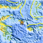
| Location | 2.155°S, 125.058°E |
| Depth | 5.1 km (3.2 miles) |
| Region | KEPULAUAN SULA, INDONESIA |
| Distances | 346 km (214 miles) NE of Kendari, Sulawesi, Indonesia 372 km (231 miles) SE of Gorontalo, Sulawesi, Indonesia 711 km (441 miles) N of DILI, Timor-Leste 1307 km (812 miles) NNW of DARWIN, Northern Territory, Australia |
| Location Uncertainty | horizontal +/- 16.4 km (10.2 miles); depth +/- 4.1 km (2.5 miles) |
| Parameters | NST= 63, Nph= 70, Dmin=>999 km, Rmss=1.12 sec, Gp= 68°, M-type=body wave magnitude (Mb), Version=6 |
| Source |
|
| Event ID | usc0005wnv |
- Did you feel it? Report shaking and damage at your location. You can also view a map displaying accumulated data from your report and others.

Earthquake Maps


Scientific & Technical Information
 Historic Moment Tensor Solutions
 Tsunami Information
The earthquake locations and magnitudes cited in NOAA tsunami statements and bulletins are preliminary and are superseded by USGS locations and magnitudes computed using more extensive data sets.
General Tsunami Information
- Preliminary Earthquake Report
- U.S. Geological Survey, National Earthquake Information Center:
World Data Center for Seismology, Denver
