
Magnitude 4.5 - KEPULAUAN BATU, INDONESIA
2011 September 18 06:45:40 UTC
Earthquake Details
- This event has been reviewed by a seismologist.
| Magnitude | 4.5 |
|---|---|
| Date-Time |
|
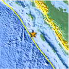
| Location | 0.955°S, 97.838°E |
| Depth | 28.1 km (17.5 miles) |
| Region | KEPULAUAN BATU, INDONESIA |
| Distances | 279 km (173 miles) W of Padang, Sumatra, Indonesia 302 km (187 miles) SSW of Padangsidempuan, Sumatra, Indonesia 625 km (388 miles) SW of KUALA LUMPUR, Malaysia 1153 km (716 miles) WNW of JAKARTA, Java, Indonesia |
| Location Uncertainty | horizontal +/- 27.8 km (17.3 miles); depth +/- 8.5 km (5.3 miles) |
| Parameters | NST= 21, Nph= 24, Dmin=382.9 km, Rmss=0.88 sec, Gp=216°, M-type=body wave magnitude (Mb), Version=6 |
| Source |
|
| Event ID | usc0005wf1 |
- Did you feel it? Report shaking and damage at your location. You can also view a map displaying accumulated data from your report and others.

Earthquake Maps


Scientific & Technical Information
 Historic Moment Tensor Solutions
- Preliminary Earthquake Report
- U.S. Geological Survey, National Earthquake Information Center:
World Data Center for Seismology, Denver
