
Magnitude 4.1 - QUEENSLAND, AUSTRALIA
2011 September 17 16:28:29 UTC
Earthquake Details
- This event has been reviewed by a seismologist.
| Magnitude | 4.1 |
|---|---|
| Date-Time |
|
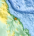
| Location | 20.214°S, 147.614°E |
| Depth | 5 km (3.1 miles) (poorly constrained) |
| Region | QUEENSLAND, AUSTRALIA |
| Distances | 136 km (84 miles) SE of Townsville, Queensland, Australia 140 km (86 miles) E of Charters Towers, Queensland, Australia 977 km (607 miles) NW of BRISBANE, Queensland, Australia 1678 km (1042 miles) N of CANBERRA, A.C.T., Australia |
| Location Uncertainty | horizontal +/- 25.9 km (16.1 miles); depth +/- 9.6 km (6.0 miles) |
| Parameters | Nph= 0, Dmin=0 km, Rmss=1.21 sec, Gp= 0, M-type=local magnitude (ML), Version=3 |
| Source |
|
| Event ID | usc0005wev |
- Did you feel it? Report shaking and damage at your location. You can also view a map displaying accumulated data from your report and others.

Earthquake Maps


Scientific & Technical Information
- Preliminary Earthquake Report
- U.S. Geological Survey, National Earthquake Information Center:
World Data Center for Seismology, Denver
