
Magnitude 4.2 - FIJI REGION
2011 September 17 05:03:32 UTC
Earthquake Details
- This event has been reviewed by a seismologist.
| Magnitude | 4.2 |
|---|---|
| Date-Time |
|
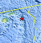
| Location | 17.544°S, 178.757°W |
| Depth | 543.4 km (337.7 miles) |
| Region | FIJI REGION |
| Distances | 233 km (144 miles) ESE of Lambasa, Vanua Levu, Fiji 306 km (190 miles) ENE of SUVA, Viti Levu, Fiji 344 km (213 miles) N of Ndoi Island, Fiji 2234 km (1388 miles) NNE of Auckland, New Zealand |
| Location Uncertainty | horizontal +/- 51.2 km (31.8 miles); depth +/- 11.4 km (7.1 miles) |
| Parameters | NST= 82, Nph= 84, Dmin=849.4 km, Rmss=0.61 sec, Gp=176°, M-type=body wave magnitude (Mb), Version=7 |
| Source |
|
| Event ID | usc0005w3r |
- Did you feel it? Report shaking and damage at your location. You can also view a map displaying accumulated data from your report and others.
Earthquake Maps


Scientific & Technical Information
 Historic Moment Tensor Solutions
- Preliminary Earthquake Report
- U.S. Geological Survey, National Earthquake Information Center:
World Data Center for Seismology, Denver
