
Magnitude 4.9 - SANTA CRUZ ISLANDS
2011 September 17 01:32:55 UTC
Earthquake Details
- This event has been reviewed by a seismologist.
| Magnitude | 4.9 |
|---|---|
| Date-Time |
|
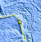
| Location | 12.217°S, 165.844°E |
| Depth | 45.6 km (28.3 miles) |
| Region | SANTA CRUZ ISLANDS |
| Distances | 166 km (103 miles) S of Lata, Santa Cruz Islands, Solomon Isl. 393 km (244 miles) NNW of Luganville, Espiritu Santo, Vanuatu 665 km (413 miles) NNW of PORT-VILA, Efate, Vanuatu 2156 km (1339 miles) NE of BRISBANE, Queensland, Australia |
| Location Uncertainty | horizontal +/- 20.9 km (13.0 miles); depth +/- 11.3 km (7.0 miles) |
| Parameters | NST= 35, Nph= 37, Dmin=714.7 km, Rmss=0.92 sec, Gp= 65°, M-type=body wave magnitude (Mb), Version=6 |
| Source |
|
| Event ID | usc0005w25 |
- Did you feel it? Report shaking and damage at your location. You can also view a map displaying accumulated data from your report and others.
Earthquake Maps


Scientific & Technical Information
 Historic Moment Tensor Solutions
- Preliminary Earthquake Report
- U.S. Geological Survey, National Earthquake Information Center:
World Data Center for Seismology, Denver
