
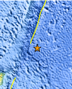
Magnitude 6.0 - EAST OF THE NORTH ISLAND, NEW ZEALAND
2011 September 15 07:53:12 UTC
Earthquake Details
- This event has been reviewed by a seismologist.
| Magnitude | 6.0 |
|---|---|
| Date-Time |
|
| Location | 35.430°S, 177.878°W |
| Depth | 13.4 km (8.3 miles) |
| Region | EAST OF THE NORTH ISLAND, NEW ZEALAND |
| Distances | 453 km (281 miles) SSE of L'Esperance Rock, Kermadec Islands 512 km (318 miles) NE of Gisborne, New Zealand 680 km (422 miles) ENE of Auckland, New Zealand 913 km (567 miles) NE of WELLINGTON, New Zealand |
| Location Uncertainty | horizontal +/- 27.8 km (17.3 miles); depth +/- 7.5 km (4.7 miles) |
| Parameters | NST= 53, Nph= 53, Dmin=416.3 km, Rmss=1.32 sec, Gp=148°, M-type=regional moment magnitude (Mw), Version=8 |
| Source |
|
| Event ID | usc0005urf |
- Did you feel it? Report shaking and damage at your location. You can also view a map displaying accumulated data from your report and others.
Earthquake Maps


Scientific & Technical Information

 Tsunami Information
The earthquake locations and magnitudes cited in NOAA tsunami statements and bulletins are preliminary and are superseded by USGS locations and magnitudes computed using more extensive data sets.
General Tsunami Information
- Preliminary Earthquake Report
- U.S. Geological Survey, National Earthquake Information Center:
World Data Center for Seismology, Denver
