
Magnitude 5.3 - SOUTHWEST OF SUMATRA, INDONESIA
2011 September 14 15:54:50 UTC
Earthquake Details
- This event has been reviewed by a seismologist.
| Magnitude | 5.3 |
|---|---|
| Date-Time |
|
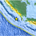
| Location | 6.232°S, 103.642°E |
| Depth | 31.4 km (19.5 miles) |
| Region | SOUTHWEST OF SUMATRA, INDONESIA |
| Distances | 216 km (134 miles) WSW of T.-Telukbetung, Sumatra, Indonesia 281 km (174 miles) W of Cilegon, Java, Indonesia 317 km (196 miles) SSE of Bengkulu, Sumatra, Indonesia 364 km (226 miles) W of JAKARTA, Java, Indonesia |
| Location Uncertainty | horizontal +/- 16.9 km (10.5 miles); depth +/- 6.2 km (3.9 miles) |
| Parameters | NST=138, Nph=141, Dmin=220.4 km, Rmss=0.66 sec, Gp= 83°, M-type=body wave magnitude (Mb), Version=A |
| Source |
|
| Event ID | usc0005u9r |
- Did you feel it? Report shaking and damage at your location. You can also view a map displaying accumulated data from your report and others.
Earthquake Maps


Scientific & Technical Information
 Historic Moment Tensor Solutions
- Preliminary Earthquake Report
- U.S. Geological Survey, National Earthquake Information Center:
World Data Center for Seismology, Denver
