
Magnitude 6.2 - NEAR NORTH COAST OF NEW GUINEA, P.N.G.
2011 September 12 22:44:31 UTC
Earthquake Details
- This event has been reviewed by a seismologist.
| Magnitude | 6.2 |
|---|---|
| Date-Time |
|
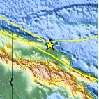
| Location | 3.638°S, 144.160°E |
| Depth | 34.9 km (21.7 miles) |
| Region | NEAR NORTH COAST OF NEW GUINEA, P.N.G. |
| Distances | 48 km (29 miles) ESE of Wewak, New Guinea, PNG 242 km (150 miles) N of Mount Hagen, New Guinea, PNG 728 km (452 miles) NNW of PORT MORESBY, Papua New Guinea 2803 km (1741 miles) NNW of BRISBANE, Queensland, Australia |
| Location Uncertainty | horizontal +/- 12.6 km (7.8 miles); depth +/- 2.6 km (1.6 miles) |
| Parameters | NST=317, Nph=335, Dmin=397.4 km, Rmss=0.98 sec, Gp= 14°, M-type=regional moment magnitude (Mw), Version=A |
| Source |
|
| Event ID | usc0005tbb |
- Did you feel it? Report shaking and damage at your location. You can also view a map displaying accumulated data from your report and others.

Earthquake Maps


Scientific & Technical Information

 Tsunami Information
The earthquake locations and magnitudes cited in NOAA tsunami statements and bulletins are preliminary and are superseded by USGS locations and magnitudes computed using more extensive data sets.
General Tsunami Information
- Preliminary Earthquake Report
- U.S. Geological Survey, National Earthquake Information Center:
World Data Center for Seismology, Denver
