
Magnitude 5.0 - SOUTHWEST OF SUMATRA, INDONESIA
2011 September 12 18:23:55 UTC
Earthquake Details
- This event has been reviewed by a seismologist.
| Magnitude | 5.0 |
|---|---|
| Date-Time |
|
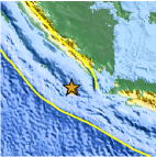
| Location | 6.487°S, 103.636°E |
| Depth | 14.7 km (9.1 miles) |
| Region | SOUTHWEST OF SUMATRA, INDONESIA |
| Distances | 213 km (132 miles) WSW of T.-Telukbetung, Sumatra, Indonesia 272 km (169 miles) WSW of Cilegon, Java, Indonesia 334 km (207 miles) SSE of Bengkulu, Sumatra, Indonesia 354 km (219 miles) W of JAKARTA, Java, Indonesia |
| Location Uncertainty | horizontal +/- 20.5 km (12.7 miles); depth +/- 7.7 km (4.8 miles) |
| Parameters | NST= 49, Nph= 49, Dmin=414.1 km, Rmss=1.23 sec, Gp=158°, M-type=body wave magnitude (Mb), Version=4 |
| Source |
|
| Event ID | usc0005t0k |
- Did you feel it? Report shaking and damage at your location. You can also view a map displaying accumulated data from your report and others.
Earthquake Maps


Scientific & Technical Information
 Historic Moment Tensor Solutions
- Preliminary Earthquake Report
- U.S. Geological Survey, National Earthquake Information Center:
World Data Center for Seismology, Denver
