
Magnitude 4.8 - KERMADEC ISLANDS, NEW ZEALAND
2011 September 12 07:05:19 UTC
Earthquake Details
- This event has been reviewed by a seismologist.
| Magnitude | 4.8 |
|---|---|
| Date-Time |
|
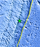
| Location | 30.626°S, 178.094°W |
| Depth | 98.7 km (61.3 miles) |
| Region | KERMADEC ISLANDS, NEW ZEALAND |
| Distances | 117 km (72 miles) NE of L'Esperance Rock, Kermadec Islands 152 km (94 miles) S of Raoul Island, Kermadec Islands 957 km (594 miles) NE of Auckland, New Zealand 1091 km (677 miles) SSW of NUKU`ALOFA, Tonga |
| Location Uncertainty | horizontal +/- 19.5 km (12.1 miles); depth +/- 11.3 km (7.0 miles) |
| Parameters | NST= 42, Nph= 42, Dmin=153.6 km, Rmss=0.97 sec, Gp= 76°, M-type=body wave magnitude (Mb), Version=4 |
| Source |
|
| Event ID | usc0005srd |
- Did you feel it? Report shaking and damage at your location. You can also view a map displaying accumulated data from your report and others.
Earthquake Maps


Scientific & Technical Information
 Historic Moment Tensor Solutions
- Preliminary Earthquake Report
- U.S. Geological Survey, National Earthquake Information Center:
World Data Center for Seismology, Denver
