
Magnitude 4.8 - KEPULAUAN TALAUD, INDONESIA
2011 September 11 01:58:59 UTC
Earthquake Details
- This event has been reviewed by a seismologist.
| Magnitude | 4.8 |
|---|---|
| Date-Time |
|
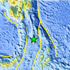
| Location | 3.524°N, 126.845°E |
| Depth | 71.8 km (44.6 miles) |
| Region | KEPULAUAN TALAUD, INDONESIA |
| Distances | 308 km (191 miles) N of Ternate, Moluccas, Indonesia 314 km (195 miles) NE of Manado, Sulawesi, Indonesia 947 km (588 miles) WSW of KOROR, Palau 1384 km (859 miles) SSE of MANILA, Philippines |
| Location Uncertainty | horizontal +/- 18.5 km (11.5 miles); depth +/- 12 km (7.5 miles) |
| Parameters | NST= 29, Nph= 30, Dmin=931.7 km, Rmss=1.37 sec, Gp=104°, M-type=body wave magnitude (Mb), Version=4 |
| Source |
|
| Event ID | usc0005sfi |
- Did you feel it? Report shaking and damage at your location. You can also view a map displaying accumulated data from your report and others.

Earthquake Maps


Scientific & Technical Information
 Historic Moment Tensor Solutions
- Preliminary Earthquake Report
- U.S. Geological Survey, National Earthquake Information Center:
World Data Center for Seismology, Denver
