
Magnitude 4.8 - TONGA
2011 September 09 02:46:22 UTC
Earthquake Details
- This event has been reviewed by a seismologist.
| Magnitude | 4.8 |
|---|---|
| Date-Time |
|
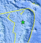
| Location | 17.194°S, 174.557°W |
| Depth | 121.3 km (75.4 miles) |
| Region | TONGA |
| Distances | 162 km (100 miles) SSW of Hihifo, Tonga 172 km (106 miles) NNW of Neiafu, Tonga 441 km (274 miles) N of NUKU`ALOFA, Tonga 2420 km (1503 miles) NNE of Auckland, New Zealand |
| Location Uncertainty | horizontal +/- 24 km (14.9 miles); depth +/- 10.2 km (6.3 miles) |
| Parameters | NST=168, Nph=169, Dmin=469.8 km, Rmss=0.72 sec, Gp=122°, M-type=body wave magnitude (Mb), Version=8 |
| Source |
|
| Event ID | usc0005rh6 |
- Did you feel it? Report shaking and damage at your location. You can also view a map displaying accumulated data from your report and others.
Earthquake Maps


Scientific & Technical Information
 Historic Moment Tensor Solutions
- Preliminary Earthquake Report
- U.S. Geological Survey, National Earthquake Information Center:
World Data Center for Seismology, Denver
