
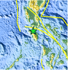
Magnitude 4.6 - MINDORO, PHILIPPINES
2011 September 08 15:19:47 UTC
Earthquake Details
- This event has been reviewed by a seismologist.
| Magnitude | 4.6 |
|---|---|
| Date-Time |
|
| Location | 13.484°N, 120.900°E |
| Depth | 93.4 km (58.0 miles) |
| Region | MINDORO, PHILIPPINES |
| Distances | 32 km (19 miles) WNW of Calapan, Mindoro, Philippines 35 km (21 miles) SSW of Batangas, Luzon, Philippines 125 km (77 miles) S of MANILA, Philippines 162 km (100 miles) WSW of San Pedro, Luzon, Philippines |
| Location Uncertainty | horizontal +/- 18 km (11.2 miles); depth +/- 10 km (6.2 miles) |
| Parameters | NST= 33, Nph= 35, Dmin=956.2 km, Rmss=0.56 sec, Gp= 90°, M-type=body wave magnitude (Mb), Version=4 |
| Source |
|
| Event ID | usc0005r25 |
- Did you feel it? Report shaking and damage at your location. You can also view a map displaying accumulated data from your report and others.

Earthquake Maps


Scientific & Technical Information
 Historic Moment Tensor Solutions
- Preliminary Earthquake Report
- U.S. Geological Survey, National Earthquake Information Center:
World Data Center for Seismology, Denver
