
Magnitude 4.9 - FIJI
2011 September 08 08:58:47 UTC
Earthquake Details
- This event has been reviewed by a seismologist.
| Magnitude | 4.9 |
|---|---|
| Date-Time |
|
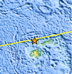
| Location | 16.466°S, 177.842°E |
| Depth | 21.3 km (13.2 miles) |
| Region | FIJI |
| Distances | 133 km (82 miles) NNE of Lautoka, Viti Levu, Fiji 164 km (101 miles) W of Lambasa, Vanua Levu, Fiji 194 km (120 miles) NNW of SUVA, Viti Levu, Fiji 2280 km (1416 miles) N of Auckland, New Zealand |
| Location Uncertainty | horizontal +/- 25.8 km (16.0 miles); depth +/- 7 km (4.3 miles) |
| Parameters | NST= 90, Nph= 91, Dmin=143.6 km, Rmss=0.61 sec, Gp=112°, M-type=body wave magnitude (Mb), Version=5 |
| Source |
|
| Event ID | usc0005qyr |
- Did you feel it? Report shaking and damage at your location. You can also view a map displaying accumulated data from your report and others.
Earthquake Maps


Scientific & Technical Information
 Historic Moment Tensor Solutions
- Preliminary Earthquake Report
- U.S. Geological Survey, National Earthquake Information Center:
World Data Center for Seismology, Denver
