
Magnitude 4.3 - BANDA SEA
2011 September 07 10:06:56 UTC
Earthquake Details
- This event has been reviewed by a seismologist.
| Magnitude | 4.3 |
|---|---|
| Date-Time |
|
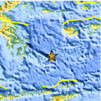
| Location | 5.429°S, 125.098°E |
| Depth | 11.7 km (7.3 miles) |
| Region | BANDA SEA |
| Distances | 277 km (172 miles) E of Baubau, Sulawesi, Indonesia 328 km (203 miles) ESE of Kendari, Sulawesi, Indonesia 349 km (216 miles) N of DILI, Timor-Leste 1001 km (621 miles) NW of DARWIN, Northern Territory, Australia |
| Location Uncertainty | horizontal +/- 25.7 km (16.0 miles); depth +/- 11.6 km (7.2 miles) |
| Parameters | NST= 18, Nph= 18, Dmin=487.6 km, Rmss=0.52 sec, Gp=101°, M-type=body wave magnitude (Mb), Version=3 |
| Source |
|
| Event ID | usc0005q7s |
- Did you feel it? Report shaking and damage at your location. You can also view a map displaying accumulated data from your report and others.

Earthquake Maps


Scientific & Technical Information
 Historic Moment Tensor Solutions
- Preliminary Earthquake Report
- U.S. Geological Survey, National Earthquake Information Center:
World Data Center for Seismology, Denver
