
Magnitude 5.5 - SOUTH OF THE KERMADEC ISLANDS
2011 September 06 10:51:33 UTC
Earthquake Details
- This event has been reviewed by a seismologist.
| Magnitude | 5.5 |
|---|---|
| Date-Time |
|
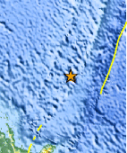
| Location | 34.096°S, 179.469°E |
| Depth | 9.8 km (6.1 miles) |
| Region | SOUTH OF THE KERMADEC ISLANDS |
| Distances | 332 km (206 miles) SSW of L'Esperance Rock, Kermadec Islands 523 km (324 miles) NNE of Gisborne, New Zealand 526 km (326 miles) NE of Auckland, New Zealand 899 km (558 miles) NNE of WELLINGTON, New Zealand |
| Location Uncertainty | horizontal +/- 18.6 km (11.6 miles); depth +/- 7.6 km (4.7 miles) |
| Parameters | NST= 83, Nph= 83, Dmin=508.7 km, Rmss=1.16 sec, Gp= 76°, M-type=body wave magnitude (Mb), Version=A |
| Source |
|
| Event ID | usc0005ppb |
- Did you feel it? Report shaking and damage at your location. You can also view a map displaying accumulated data from your report and others.
Earthquake Maps


Scientific & Technical Information

 Tsunami Information
The earthquake locations and magnitudes cited in NOAA tsunami statements and bulletins are preliminary and are superseded by USGS locations and magnitudes computed using more extensive data sets.
General Tsunami Information
- Preliminary Earthquake Report
- U.S. Geological Survey, National Earthquake Information Center:
World Data Center for Seismology, Denver
