
Magnitude 3.8 - NEAR THE COAST OF SOUTH AUSTRALIA
2011 September 04 11:15:11 UTC
Earthquake Details
- This event has been reviewed by a seismologist.
| Magnitude | 3.8 |
|---|---|
| Date-Time |
|
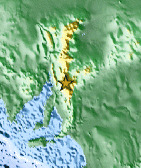
| Location | 33.079°S, 138.713°E |
| Depth | 2 km (1.2 miles) (poorly constrained) |
| Region | NEAR THE COAST OF SOUTH AUSTRALIA |
| Distances | 109 km (67 miles) SE of Port Augusta, South Australia, Australia 205 km (127 miles) N of ADELAIDE, South Australia, Australia 774 km (480 miles) NW of MELBOURNE, Victoria, Australia 998 km (620 miles) W of CANBERRA, A.C.T., Australia |
| Location Uncertainty | horizontal +/- 30.4 km (18.9 miles); depth +/- 13.3 km (8.3 miles) |
| Parameters | Nph= 0, Dmin=0 km, Rmss=2.13 sec, Gp= 0, M-type=local magnitude (ML), Version=3 |
| Source |
|
| Event ID | usc0005p7q |
- Did you feel it? Report shaking and damage at your location. You can also view a map displaying accumulated data from your report and others.

Earthquake Maps


Scientific & Technical Information
- Preliminary Earthquake Report
- U.S. Geological Survey, National Earthquake Information Center:
World Data Center for Seismology, Denver
