
Magnitude 6.1 - VANUATU
2011 September 04 21:44:21 UTC
Earthquake Details
- This event has been reviewed by a seismologist.
| Magnitude | 6.1 |
|---|---|
| Date-Time |
|
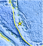
| Location | 19.156°S, 168.696°E |
| Depth | 59.4 km (36.9 miles) |
| Region | VANUATU |
| Distances | 73 km (45 miles) NW of Isangel, Tanna, Vanuatu 163 km (101 miles) SSE of PORT-VILA, Efate, Vanuatu 278 km (172 miles) NNE of Tadine, Loyalty Islands, New Caledonia 1848 km (1148 miles) ENE of BRISBANE, Queensland, Australia |
| Location Uncertainty | horizontal +/- 14.7 km (9.1 miles); depth +/- 5.6 km (3.5 miles) |
| Parameters | NST=165, Nph=165, Dmin=>999 km, Rmss=0.99 sec, Gp= 79°, M-type=regional moment magnitude (Mw), Version=6 |
| Source |
|
| Event ID | usc0005p3i |
- Did you feel it? Report shaking and damage at your location. You can also view a map displaying accumulated data from your report and others.
Earthquake Maps


Scientific & Technical Information

 Tsunami Information
The earthquake locations and magnitudes cited in NOAA tsunami statements and bulletins are preliminary and are superseded by USGS locations and magnitudes computed using more extensive data sets.
General Tsunami Information
- Preliminary Earthquake Report
- U.S. Geological Survey, National Earthquake Information Center:
World Data Center for Seismology, Denver
